At midday the barrier island in Vero Beach has the weird feel of a place quickly and angrily abandoned. Poking around debris-lined streets among spray-painted signs all denigrating a certain Jeanne, I’m hoping not to be mistaken for a looter by a cop—or, worse yet, by an armed Floridian homeowner. Wind gusts drive intermittent sheets of rain as a few stragglers throw a last suitcase or heirloom into a car before scurrying over the causeway to the mainland. Jeanne, you see, is a major hurricane, already a killer of thousands in Haiti. This thin strip of land is surely not the place to be when she arrives in full force tonight.
The ghost town air of shuttered, boarded-up, duct-taped houses and condos prevails everywhere but the oceanfront, where visitors keep arriving. Police officers try to shoo them away. “We’re under an evacuation order here, folks,” they announce. “Don’t even think about it!” a patrolman bellows at a pair of daredevils who drive up with surfboards strapped to their car. But as soon as the officers move off to another public beach, more hurricane pilgrims appear. Mostly they’re locals who’ve come to curse at fate, or to ponder nature’s cruel sense of humor, or maybe just to wearily accept what’s coming.
Again.
Three weeks ago a cyclone named Frances tore into central Florida on a nearly identical path. That hurricane, the second to hit the state in the unlucky summer of 2004, left several feet of water in Greg McIntosh’s house. Turning his back to a hard blast of wind, he wonders what Jeanne—storm number four—has in store.
“It’s like in basic training when you get into your bivouac and then the sergeant blows the whistle and you have to go another ten miles in the dark,” says McIntosh.
David Mitchell, a recent transplant to Florida, leans on the railing above a seawall and stares over the rising sea. Monstrous swells crash into a breakwater a few hundred yards offshore.
“I’ve only been here four months, and in that time, two hurricanes,” he says. He’ll soon retreat to his apartment, where he has taped over the windows, even though that’s not likely to offer much protection from windblown debris. “I guess when you live in Florida, it’s just something you have to get used to.”
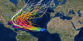
Not just Floridians—anyone in the eastern coastal regions of the United States and Central America, as well as the entire Caribbean, is getting used to it. Since 1995 the Atlantic has been producing powerful hurricanes at a hyperactive pace, doubling that of the previous quarter century. If few in the U.S. noticed at first, it was because atmospheric conditions mostly kept the abundant storms out at sea or headed elsewhere. But the winds shifted in 2004.
“The whole East Coast was very lucky for the past 30 or 40 years,” says William Gray, of Colorado State University, a pioneer in long-range hurricane research and forecasting. Gray had predicted a damaging storm season for last year. “We’d been saying things would change, but nobody expected anything like the 2004 season.”
The coming hurricane seasons might make last year’s estimated 40 billion dollars’ worth of U.S. damage look small. Warns Gray: “There’s no way—if we see a return to the type of landfall activity we saw in the thirties, forties, and fifties—no way but that economic losses will double, triple, quadruple, or worse.”
That’s because societal risk—roughly defined as the number of people and value of property vulnerable to hurricanes—has exploded. The southeastern coastal population has grown dramatically, with Florida’s alone more than tripling since 1960. The economic risk has also multiplied. About 1.1 trillion dollars’ worth of at-risk property was insured in 1980; the total now is an estimated 5.5 trillion dollars’ worth. And the latest census figures show that between 2000 and 2004, 29 of the 50 fastest-growing U.S. counties were in East Coast and Gulf Coast states.
The hurricane glut is happening at the same time sea levels continue to rise—the result of global warming that most scientists blame in part on human activity. A recent study using the latest computer climate models predicts warming of the tropical sea surface will strengthen hurricane winds and rainfall by the end of the 21st century. However, some experts, including Gray, argue that climate change due to human activity will not significantly affect hurricanes.
That debate will continue, but many scientists agree that the present hurricane surge is likely part of a 60-to-70-year cycle that changes the strength of ocean currents distributing heat around the globe. Researchers have used tree rings and ice cores to track this variability back hundreds of years. We’re now in a fast-flowing mode of this up-and-down cycle, named the Atlantic Multidecadal Oscillation (AMO), during which Atlantic sea-surface temperatures and wind conditions favor hurricane generation. Ten years from now, or perhaps thirty (the timetable is difficult to predict), the cycle should reverse, tending to suppress major hurricanes.
Why the variation? “Frankly, no one can say with 100 percent certainty, but it appears to be a natural effect,” says Thomas Delworth, a climate modeler at NOAA’s Geophysical Fluid Dynamics Laboratory in Princeton, New Jersey. Delworth is part of a major scientific effort to develop accurate computer climate models, and much of his work focuses on thermohaline circulation—that is, the way ocean currents, and consequently such cycles as the AMO, are driven by heat and salinity.
Thermohaline circulation runs the Atlantic conveyor belt, part of a global ocean system in which a continuous flow of upper-level water is drawn from the tropical Atlantic north toward the Pole. There the water cools, sinks, and cycles back to the southern oceans in deepwater currents.
As the conveyor belt speeds up, tropical surface water is drawn north more quickly, and temperatures in the North Atlantic are as much as 2°F warmer. That’s good for hurricanes. “A hurricane is essentially an engine that runs on heat,” says Chris Landsea, a meteorologist at NOAA’s Hurricane Research Division in Miami. “The warmer the sea-surface temperature [it must be at least 80°F for a hurricane to start] and the more warm, moist air that’s available, the stronger a hurricane can become.”
How and where does the conveyor belt speed up, increasing the overturning circulation of warm and cold water? It’s at the point where cold surface water sinks that the acceleration of the Atlantic conveyor belt probably happens, Delworth says. Cold, dry air coming off Canada extracts heat from the water. When these winds blow stronger and colder than average over a number of years, increasingly chilled water sinks faster because it is more dense, intensifying the flow rate. Years of weaker and warmer winds have the opposite effect, slowing the conveyor belt.
Climate records indicate a correlation between a pattern of increased cold winds and the 1995 upswing in hurricane formation. “From the late sixties to the mid-nineties, westerly winds strengthened,” Delworth says. “The overturning circulation probably increased in that period in response.”
Increased circulation brings mighty storms—born as air spirals into a low-pressure zone charged with warm, humid air over warmer sea surfaces. The winds meet and ascend, causing clouds to billow upward, further lowering air pressure and causing winds to barrel even faster toward the center. The Earth’s rotation lends spin to the gathering cyclone. When water vapor in the ascending clouds cools and falls as rain, the amount of heat energy released dwarfs the amount of electricity consumed daily by all of humanity. The energy warms the eye, further lowering the pressure and strengthening the storm.
The cyclone can continue to strengthen if atmospheric currents guide it over warm water, and if it is not destroyed by vertical wind shear—the differential between wind speeds at lower and higher altitudes. Strong wind shear can dissipate a storm, but the warm phase of the AMO tends to weaken vertical wind shear in the Atlantic.
The combined effect of changes in the AMO and the Atlantic conveyor belt has been dramatic. In the Caribbean, production of cyclones skyrocketed 400 percent. In the entire Atlantic Basin, major hurricanes, with sustained winds of 111 miles an hour (179 kilometers an hour) or higher, increased 150 percent. The intensifying is most pronounced in powerful storms like Ivan, whose winds at times exceeded 155 miles an hour (250 kilometers an hour) as it smashed past Jamaica and headed for landfall near Pensacola.
It was just after midnight on September 16, 2004. Residents of Grande Lagoon who chose to ignore evacuation warnings and ride Ivan out in their upscale homes flanking the Intracoastal Waterway west of Pensacola passed time reading, playing cards with their children, wondering if they had miscalculated.
The cacophony of wind and debris pelting their houses covered up any sound that might signal the approach of the real enemy—not wind, but a wide dome of seawater Ivan had piled up and was pushing toward them in the dark. This was the storm surge, the deadliest part of a hurricane for those living near water. Two men who survived the sudden flooding related this same sequence of events: They looked down first at a wet floor, then at a few inches of water around their feet. Each then opened the front door to a waist-deep onslaught of dirty seawater.
Three others who refused to evacuate the area died when the sea invaded their homes. The search for bodies delayed the return of residents who evacuated and then came back wanting to know what they had lost. For many, that turned out to be everything they didn’t take with them when they fled.
In the chaos of the aftermath, one couple in the neighborhood seems somewhat at home. Al and Dean Hoffman have set up camp in a tent trailer outside their devastated ranch house. At the moment, there’s enough wood debris heaped against the house, which backs water, to rebuild several docks. A motorboat has pierced a side room. The interior is muck-coated and smells of rotting fish. But the retired couple will not be pushed from the coastline a second time.
“I came back to a concrete pad after Hugo hit South Carolina in 1989, so I can handle this,” says Dean Hoffman. “We sure know how to pick ’em, don’t we?” adds her husband, Al.
A big topic of conversation in hurricane-flooded communities is FEMA’s “50 percent rule.” If inspectors from the federal disaster agency determine that a house has sustained more than 50 percent damage, the structure must be rebuilt to the latest state and local codes. This rule protects the government-run National Flood Insurance Program—which pays up to $250,000 for reconstruction—from repeatedly covering repairs to the same house. For Dean and Al the latest codes could require a new house on 10- or 15-foot (3- to 5-meter) pilings. “My God—can you imagine how ridiculous that would be?” Al asks, glancing up, perhaps imagining a ranch house among the trees. There’s no way his waterlogged home is more than half done for, he declares.
According to the latest National Hurricane Center updates, which I’m monitoring the morning of September 25 in my Vero Beach hotel room, Jeanne has traversed luxuriously warm water and is now a major hurricane. As I study satellite images of the rotating cloud mass on the NOAA website, I’m perversely pleased that my first hurricane won’t be of the garden variety.
I might be less sanguine were I not planning to ride out the storm in an absolute bunker of a house a few miles inland. I’ll be at the home of Jonathan Gorham, coastal engineer for Indian River County. His house was built in 2003 to all the latest hurricane codes. Gorham and his wife have also invited two other families to weather the hurricane with them. Their houses were seriously damaged by Frances and might not stand up to Jeanne’s pounding.
Our group, assembled and under assault by early evening, has been waiting for the calm of the storm’s eye. But sometime after midnight we realize there will be no letup—the eye is passing just south of us. “I’ve heard you can see the stars come out in the eye,” says Mike Bresette, dejected, as he turns in for the night. I’m on a bedroll near the front door, which seems to bow inward with each hard gust. With the rumbling that’s coming through the thick walls of the Gorham house, I begin to feel in my bones a measure of the fear many millions have known for as long as humans have lived near oceans.
So I’m deflated to learn some weeks later that for all its fury, the storm, where I was, was perhaps not all it was advertised to be. This news comes from Tim Reinhold, vice president of engineering at the Institute for Business and Home Safety, a research and education organization funded by the insurance industry. Reinhold, a former civil engineering professor, rode out each 2004 Florida hurricane while tending wind gauges and other instruments he set up at houses in the paths of the storms.
Jeanne’s maximum sustained wind speed at landfall was 120 miles an hour (190 kilometers an hour). But slightly inland, the best Reinhold’s instruments could offer was 87 miles an hour (140 kilometers an hour)—a piddling Category One event. Charley, in August, remained genuinely powerful over land; the others lost significant force.
So what, exactly, is a major hurricane? “There’s more than one kind of measurement, especially when we’re trying to measure what people went through in the places they live,” Reinhold says. But one thing is certain: Last season’s devastation could easily pale in seasons to come before the current cycle reverses.
“When you looked at images of Jeanne, Frances, or Ivan, you didn’t see a complete doughnut-shaped eye wall like you see in a really powerful hurricane,” Reinhold says. “You see that in images of Andrew in ’92. Andrew looked like a buzz saw.” William Gray and his colleagues, who predicted last year’s above-average probability of destruction, have done so again for this year. It may turn out the hurricanes of 2004 were but a wake-up call. The buzz saws might already be winding up far out at sea.


